
“Commuter Crossroads”—commuting by transit and trolley
Commuter Crossroads main page
Commuting by bus
Commuting by train
Commuting by bicycle and walking
Commuting by car
More Commuter Crossroads topics
Commuter Crossroads main page
“Commuter Crossroads”—commuting by transit and trolley
Commuting by bus
Commuting by train
Commuting by bicycle and walking
Commuting by car
More Commuter Crossroads topics
Metro’s Deadly Year
Metro Tries to Cope With Inauguration Crowds
Once Again, Metro Aims for Dulles
The Great Society Subway
Dulles Rail Project Moves Ahead
Metro Communications Fall Short
Trolleys Combine Heritage, Tourism, and Transportation
Metro Increases Capacity and Security
Metro Changed the Face of Washington
VRE’s Metro Connection (Jan. 9, 2000).
By Steve Dunham
This column appeared in the Fredericksburg, VA, Free Lance–Star on
The Washington Metro just struggled through its worst year ever. The low point came on
The worst accident in Metro’s
Metro was designed to have its trains run by computer, with the operators mostly making announcements and opening and closing the doors. Until a few years ago they were generally forbidden to operate the trains manually, until a computer-driven train in an icy railyard failed to stop before reaching the end of the track and crashed, killing the operator of the train, which was carrying no passengers. After that, Metro starting granting the operators more latitude to personally take control of the trains, and after the June disaster, the transit authority switched to entirely manual operation, for fear that other track circuits would mislead another onboard computer into thinking that the track ahead was clear.
Another technology problem haunting Metro is that its oldest cars—dating from the system’s inception—are not as crash-resistant as newer ones. To help reduce the danger in any future crashes, after the Fort Totten accident Metro started placing older cars in the middle of its trains and newer, stronger cars on the ends where they would take the impact in a crash.
The Fort Totten wreck was the first time a Metrorail passenger died in more than
A year ago, an anonymous reader wrote to scold me for criticizing Metro. Didn’t I know it was the best mass-transit system in the country? At one time that might have been true. Being under the close watch of Congress has usually meant that Metro has gotten as much money as it needs to supplement the funds from the jurisdictions it serves. Yet it hasn’t had the money to replace its oldest railcars, which wasn’t a big issue until nine people died in a wreck. Indeed, the bigger management fault is probably overconfidence in the computer operation of the trains.
A group called Metroriders.org has for years been calling for dedicated funding for Metrobus and Metrorail, rather than have the agency go hat in hand to its sponsors each year. Regular annual funding could let Metro improve maintenance and safety.
New railcars, however, are typically purchased with federal capital grants for which many transit agencies compete. With mass-transit systems starting and expanding across the country, this is one area where the government needs to provide money commensurate with the need and the benefits. Overall transportation safety is one area that would benefit. I’m sure that if a large proportion of Metro’s millions of passenger trips each year had been taken by car instead, a lot more than nine people would have died in the past
Long before 2001, the Washington Metropolitan Area Transit Authority was an industry leader in security against crime and terrorism. With good management, it can once again be a leader in safety too.
By Steve Dunham
This appeared in the Fredericksburg Free Lance–Star on
Metro (the Washington Metropolitan Area Transit Authority) set another record on Inauguration Day: over one and a half million one-way trips, so about three quarters of a million people used Metro on Inauguration Day, two thirds of them on Metro’s rail system, the rest on buses. Unfortunately, the Metro rail system wasn’t prepared to handle the volume.
I didn’t think that tens of thousands of people would be heading onto the National Mall just as the sun was coming up, more than four hours before the inauguration, with the temperatures well below freezing. I was wrong. When my Virginia Railway Express train passed the Metro station at Franconia-Springfield around
When I got to L’Enfant Plaza in Washington, I and the other passengers trying to board Metro could barely enter the station because of the crowd trying to leave. Metro’s blue, orange, yellow and green lines cross here, and even though the station has several exits, the concourse was wall-to-wall people trying to get out of the station. After about
This would have been a good time for Metro to call on VRE for help. A couple of eight-car VRE trains dispatched from Washington to Franconia-Springfield could have picked up at least
What Metro did—and it helped—was to take buses and turn them into free shuttles from jammed stations such as Crystal City (in Arlington, Va.) to the Pentagon, where people could walk across the bridge to Washington. What Metro shouldn’t have done was take buses already carrying passengers and divert them. When I boarded a bus at Crystal City, the driver told the passengers that he had to load up and detour via the Pentagon. That wasn’t bad: it was only a mile out of the way, and it would help a lot of other people get where they were going. Then our bus detoured to Washington. Then the driver told us we were going back to Crystal City to become the next bus to Tyson’s Corner (where we originally were supposed to go). Then, after
Metro had a crisis on its hands, with overcrowded platforms and people unable to board trains. But part of that was due to so-called security measures. Two Metro rail stations at the Mall—Archives and Smithsonian—were closed, funneling record-breaking crowds into fewer stations with fewer stairways and escalators. I don’t believe that this made us or Obama any more secure, and it contributed to unsafe conditions for passengers.
Finally, VRE could have done better too. Originally it wasn’t going to let its regular passengers ride to work unless we purchased an extra
By Steve Dunham
This column appeared in slightly different form in the Fredericksburg, VA, Free Lance–Star on
The Washington Metro is once again aiming for Dulles International Airport. The project has been off and on track for
A year ago, the Metro extension to Dulles appeared to have everything going for it. Local funding was available from the state, the counties, and the Dulles Toll Road revenues. The Federal Transit Administration had approved the environmental impact statement. The only thing missing was the federal share of construction funding, which was less than 25% of the cost but still a large amount because the whole project would cost
In January of this year, the Federal Transit Administration pulled the rug out by announcing that the project did not qualify for federal assistance after all. The Toll Road revenues might be overestimated, said the feds; the bonds for the project created too much debt; the Airports Authority might not be able to manage the project; the Washington Metro wasn’t doing a good enough job maintaining its existing system and fleet of trains; and, from the Washington side of the Potomac, the whole thing didn’t look like such a hot idea after all.
The Federal Transit Administration’s moving goalposts are not unique to the Dulles rail project. Winning FTA approval for Norfolk’s light rail line required many changes from the original concept of the project, according to Randy Wright of Hampton Roads Transit. The FTA considers cost per rider, cost per mile, and other measures, but the standards keep changing, he said. But Norfolk did not give up, and two years from now Norfolk residents, commuters and visitors should be riding light rail: The project received a full funding grant agreement from the FTA in February 2007, and groundbreaking took place in December.
Like Norfolk, Northern Virginia was not giving up. The governor said he would work to resolve all the FTA’s concerns and make the project happen. Standing with him were Metro, the Greater Washington Board of Trade, the Dulles Area Transportation Association, the Dulles Corridor Rail Association, the Committee for Dulles, the Washington Airports Task Force and the Loudoun County, Fairfax County, Greater Reston and Dulles Regional chambers of commerce. More than
And in a decision that all the politicians swear is not political, the FTA in April changed its mind again: the Dulles rail project does meet federal standards after all. It committed
With so much political and grassroots power pushing for rail to Dulles, those authorities are likely to implement any changes demanded of them. Even if construction begins in the next year, however, a ride on the Metro to Dulles is still years away.
By Steve Dunham
This column appeared in slightly different form in the Fredericksburg, VA, Free Lance–Star on
The Washington Metro, conceived in the 1960s, was designed to be the premier rapid transit system in the United States, not just moving people or steering development patterns, but displaying a certain elegance. Even the District of Columbia’s Commission of Fine Arts, which had a say in the design of all public works, was involved, insisting, for example, that Metro’s signature curved vault station design be used in the stations that were dug initially as underground boxes.
In The Great Society Subway:
Washington, D.C., was one of the first cities to choose rapid transit rather than more highways within its boundaries, but at first it was not an easy or popular choice. Travel by automobile was ascendant, and public transit ridership was falling. The Interstate Highway System plan called for numerous highways through and around the District of Columbia. Washington architect Louis Justement proposed (in Schrag’s words) “a city shorn of many or most of its houses, shops, and side streets, filled instead with large apartment complexes, drive-in shopping centers, and high-speed arteries linked to feeder roads by cloverleaf intersections. Justement promised to end congestion and provide ample parking everywhere.” The 1959 Metropolitan Transportation Study Plan assumed, in the words of National Capital Planning Commission member McKim Norton, “a fast rush-hour commute” by car anywhere in the region. Justement’s ideas came to partial fruition in the Southwest redevelopment, which in the 1950s and 1960s bulldozed the area’s slums and replaced them with present-day L’Enfant Plaza and its environs.
Urban renewal fetched up on the Inner Loop, however. Not today’s Inner Loop (the inside circle of the Capital Beltway) but an additional, inner beltway, this and other limited-access highways would have been built through much of central Washington.
The plan “awoke the wrath of District residents,” and the city’s response was to fight the highway construction and push for rapid transit instead. Yet the new National Capital Transportation Agency was small and weak, “designed to engineer a modest rapid transit system and not rock the boat,” though even this much was strongly opposed in some quarters: Arlington’s planning director in 1962 claimed that “rapid transit for the Washington Metropolitan Areas simply will not work”; he thought helicopters would be more practical.
To create anything more than a bobtailed system of rail routes within the District of Columbia, even with the federal government providing two-thirds of the funding, Metro had to reach an agreement with Virginia and Maryland cities and counties, which would pay for and receive service. An alternatives analysis showed that a bigger system would actually be cheaper to operate.
As design of the Metro system proceeded, controversy over the highways continued. In 1966, a report by Arthur D. Little, Inc., “submitted a blistering critique of highway planning.” Little found that highway planning was “marred by inter-agency conflict and a lack of coordinated effort and direction,” with “only the most superficial attempt at area-wide comprehensive planning for long-range goals.” It said that “freeways have generally created more problems than they have solved” and recommended against “a major commitment to the highway system.” However, highways through Washington had their staunch defender in Congressman William Natcher of Kentucky, who held up Metro design and construction funding, demanding that the Three Sisters Bridge and other road projects be completed.
But Alan Boyd, the first Secretary of Transportation, was willing to listen to highway opponents, and eventually
Metro was supposed to run in the black and pay some of its own capital expenses too, but as the years progressed, it became evident that revenues would not fully cover operating expenses, especially after Metro absorbed local bus operations in 1973. It needed subsidies, and its capital funding was a separate requirement. Even decades after its founding, some continue to question its value, and it has had numerous problems in its operations, but overall it is a popular, safe, efficient system, and, according to many, well worth what it cost to build and operate.
By Steve Dunham
This column appeared in the Fredericksburg, VA, Free Lance–Star on
The Metro rail line to Dulles International Airport is changing from a dream into a plan. Last month the Federal Transit Administration granted almost
What does this mean for the Fredericksburg area? Have you ever driven to Dulles? From our house in Massaponax, it’s about
When a relative flies to Virginia for a visit, I say, “Please fly to Reagan National Airport or Baltimore-Washington International.” Then I leave the car at home and take the train to the airport. I bring an extra VRE ticket when I meet my visitor, and we take the train to Fredericksburg (the VRE ticket is also good on most Maryland Rail Commuter trains between Washington and BWI). Air travel has gotten to be enough hassle without having to drive to the airport too. I think a lot of travelers in the Fredericksburg area will feel the same way.
The Dulles Metro line will intersect VRE’s Fredericksburg line at L’Enfant Plaza in
However, rail service to Dulles is more than
A lot of people are looking forward to riding the Dulles line. Despite federal reluctance, now being overcome, Virginia has embraced the long-overdue rail service. While transportation projects elsewhere have been hampered by people saying, “Not in my back yard,” the Dulles line has been welcomed locally, with the Dulles Corridor Rail Association (a citizens’ group) being a champion for the line, insisting on rail rather than bus service. In March, the association’s president, Patty Nicoson, addressed the annual meeting of the Virginia Association of Railway Patrons (another citizens’ group), discussing progress on the project. She explained that the town of Herndon balked at paying its share toward
So far, popular demand has overcome the doubts of politicians and transportation planners and has gotten the Dulles rail corridor project under way. I’m willing to bet that popular demand will get the rail line built all the way to the airport.
By Steve Dunham
This column appeared in the Fredericksburg, VA, Free Lance–Star on
Riding Metrobuses is complicated enough. When schedules change without warning, it gets downright frustrating.
Riding Metro’s rail lines is fairly easy. You can see most of the stations from blocks away, the trains run pretty much all the time between dawn and midnight and you can just show up and expect a train within minutes. A color-coded map shows all hundred or so stations.
The Metro bus system is much more complicated—finding the bus stops, for example. A lot of them are grouped at Metrorail stations and are fairly easy to locate. Away from the rail stations, though, it gets harder. When my employer moved to Shirlington a few years ago, I used Metro’s bus map (which looks like a bowl of multicolored spaghetti) to locate several bus routes that served the neighborhood. Armed with the information that the two bus stops
Even if you know which bus line you want, you can’t necessarily just go to a bus stop and wait. Some bus routes don’t operate every day; some run every half hour or during rush hours only. In practice, this means you have to do some research before you ride.
Once you have sought out the information and are ready to ride the bus, you face one more obstacle: the information might be wrong.
This happened on the day after Christmas, when Metro, after saying it would run normal weekday service, suddenly decided to operate a different schedule. That morning, I and another passenger showed up at a bus stop in time for a scheduled bus to Shirlington. Shortly after the bus was due, one pulled up, and the driver parked and turned off the lights. He wouldn’t be leaving for almost half an hour. The bus we were waiting for had been canceled.
Not just that bus had been canceled, either. That morning, our driver informed us, Metro had decided to reduce rush-hour service and had sent some drivers home, frustrating both employees and passengers.
A reduction in service was in order. A last-minute decision was not. The federal government had announced weeks earlier that its offices would be closed on
Instead of deciding ahead of time that a reduced schedule was appropriate, Metro waited until some drivers had returned from visiting families far away and until passengers were waiting at bus stops before cutting service. Our driver said that the bus service has been run that way for years.
In some ways, including communications on the rail lines, Metro is one of the best transit systems in America. One of its innovations is the electric signs on the train platforms informing riders when the next train will arrive and where it is bound.
Out on the streets, bus riders—a huge and important part of Metro’s ridership—generally have to find their own information, and then it might be wrong.
It’s high time that Metro upgraded its bus service and communications and simplified its routes with more trunk lines, like the new Columbia Pike service. For example, I often ride the
The service pattern is partly ordered by the cities and counties served by Metro, but the jurisdictions should approve of a plan to make a lot of the bus routes more direct, with buses running more often and all day. Then Metro should publish schedules and stick to them.
By Steve Dunham
This column appeared in the Fredericksburg, VA, Free Lance–Star on
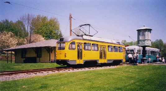 The bouncing banana from Photo copyright Steve Dunham 2003. |
Imagine riding a real trolley through Fredericksburg. It might begin its trip at the battlefield visitor center, stop at the railroad station, travel through town (maybe on Sophia Street, which has less traffic), and even go as far as Central Park, Celebrate Virginia or the National Slavery Museum. This would be a vintage or reproduction electric streetcar operating on rails—not a bus with trolley trappings, nor a full-fledged light railway like Baltimore’s. It would be North America’s 21st heritage trolley line.
Large cities such as Memphis, Tampa, and Detroit operate heritage trolleys, which dramatize the cities’ history, draw tourists, and provide everyday transportation. But heritage trolleys aren’t just for big cities. Small cities, too—including Lowell, Mass.; Kenosha, Wisc.; and Fort Collins, Colo.—have heritage trolley lines. Most of these
Fredericksburg’s heritage trolley line could operate in the street or on its own right of way or—like many heritage trolleys and light railways—do some of both. If it ran every
To get an idea of what a Fredericksburg heritage trolley line would be like, you can visit the National Capital Trolley Museum in
Sampling the trolleys gives you a taste of various decades of urban transportation, and maybe an idea of which kind of car would work best in Fredericksburg.
Admission to the grounds is free, and the grounds have a picnic grove, trolleys on display, and a museum describing the history of trolleys in general and
To get to the museum, driving to Maryland is one choice, and I did that once. On a Sunday afternoon in April, I made a better choice: I and two of my kids went by train. You can take Amtrak to Union Station in Washington, and the Metro from there to the end of the Red Line at Glenmont. The Montgomery County
The National Capital Trolley Museum is at
To learn more about the 20 existing heritage trolley operations in the United States and Canada, visit the heritage trolley website at www.heritagetrolley.org.
By Steve Dunham
This column appeared in the Fredericksburg, VA, Free Lance–Star on
The Washington Metro has some impressive improvements lined up for this year. Although Metro just might be the best transit system in America, it is still moving ahead—straining to keep up with the crowds of riders but also leading the industry with security innovations and acting to reduce pollution.
For some Fredericksburg-area commuters, Metro is the final link in the journey to their offices. For other travelers, it is the service takes them to the front door of Reagan National Airport. For families, it is the train that takes them to the National Zoo or the Air and Space Museum on weekends. Virginia Railway Express riders have five possible transfer points to Metro; Amtrak riders have two. Sometimes, however, using Metro means driving to a Metro station, particularly if you want to spend the evening in Washington.
For anyone who has driven to the Franconia-Springfield Metro station, about
Also by this summer, Metro should have all 192 of its new cars in service. About half are in operation now. Added to the
Besides expanding its fleet, Metro continues to expand its rail system. Work is under way on the Red Line station at New York Avenue and on the Blue Line extension to Largo, both of which are expected to open next year. Planning has begun for the Dulles Airport line and for the Purple Line, which would parallel the Capital Beltway in Maryland—and wouldn’t a complete Purple Line all the way around Washington be a welcome alternative to the Beltway?
Less visible are Metro’s security enhancements—in fact, some of the details are secret. In plain sight will be the additional officers on the transit police force. Less noticeable will be the security cameras being installed on
As the Washington region continues to struggle with air quality, the transit authority has made major efforts to reduce pollution. Metro begins the new year with a fleet of
For some of us, “subway” has always meant Metro. For some of us who moved to Virginia from other states, Metro is astonishingly better than some other subways we’ve ridden. With the kind of improvements the transit authority keeps making, you can see why the system keeps setting ridership records despite a sour economy.
By Steve Dunham
This column originally appeared in the Fredericksburg, VA, Free Lance–Star on
The next time you’re in
Nothing has changed the face of Washington the way Metro has, or repaid the dividends invested in it, according to
This former Metro skeptic also refutes one of the skeptics’ arguments that is still heard today: that transit-oriented development with its higher density will attract so much road traffic as to overwhelm any gains made by transit. The fact is, he said, that development focused on transit access has enabled neighborhoods to maintain a scale suited for people. For proof, he said, walk around Alexandria, Ballston, or Bethesda.
Without rapid transit, those neighborhoods, and many others in the Washington metropolitan area, would have a very different face. Washington had a trolley system—real electric trolleys on rails, not rubber-tired, gasoline-burning imitations—but the last line was abandoned in 1962, as Washington was becoming a city that depended principally on cars to take people everywhere.
Only the vigorous protests of Washington residents stopped the
Such transportation policies and choices have shaped the world we live in and work in. They have changed the face of the cities to which many of us commute, and they are changing the face of Fredericksburg and its surrounding area.
By Steve Dunham
This column appeared in the Fredericksburg, VA, Free Lance–Star
The Washington Metro is the connection of choice for people traveling to many places beyond the range of Virginia Railway Express. VRE directly serves Alexandria (near the bulk of the downtown offices), Crystal City (walking distance to everything in that corner of Arlington), L’Enfant Plaza (Federal offices and the Smithsonian museums) and Union Station (Capitol Hill and the Senate offices). The Metrorail system connects with VRE at all of those stations plus Franconia-Springfield and reaches many other points with service that ranges from superb to inconvenient.
Nearly two years of temping (1996–1998) gave me experience riding Metro not just for occasional trips but, at some assignments, every day to and from work. I commuted on every line at one time or another and discovered which connections are outstanding and which are for the desperate (I was never desperate enough to drive).
Outstanding: National Airport or the Pentagon via Metro’s Blue or Yellow Lines. Both lines stop at King St. in Alexandria, next to the VRE station. Because the Blue and Yellow Lines share track between King St. and the Pentagon, you can ride either line, and between them there’s a train every few minutes. At both National Airport and the Pentagon, Metro stops at the front door.
Also outstanding: Catholic University or Silver Spring, Md., via the Red Line. The transfer point is Union Station; VRE and Metro are at opposite ends of the building, but it’s a short walk, the Red Line has frequent service, and it’s about a ten-minute ride to downtown Silver Spring, or about five minutes to
Good: Rosslyn via the Blue Line. Transfer at Franconia-Springfield, King St., or Crystal City. Changing at Franconia-Springfield going up guarantees you a seat (it’s the beginning of the Blue Line). Coming back, VRE will have more seats at Crystal City; King St. is good in poor weather because it has a waiting room. From Crystal City to Rosslyn takes about ten minutes on the Blue Line.
Pretty good: Dupont Circle, Bethesda, Md., or Rockville, Md., via the Red Line. Change at Union Station. To Rockville it’s a one-seat Metro ride, but a long one—about 35 minutes. Dupont Circle is only about ten minutes from Union Station on Metrorail, but Metro takes you west across town after VRE has just taken you east.
Also pretty good: College Park via the Green Line. Change at L’Enfant Plaza. The one-seat ride takes around half an hour, but the Metro station at College Park is several blocks east of the University of Maryland campus.
Inconvenient: Ballston or Falls Church via the Blue and Orange Lines. In fact, anything involving a second transfer is inconvenient if you have to do it every day. I worked in Ballston for several months. I would get off VRE at Crystal City, walk to the Metro station (about two blocks, mostly indoors), wait for the Blue Line train, ride the Blue Line from Crystal City to Rosslyn, wait for the Orange Line train, then ride the Orange Line train to Ballston. In the evening it was the reverse. The two Metro
rides each way took only about ten minutes each, but the walking and waiting made it into a
The Transit Link Card is a monthly Metrorail and VRE pass printed on a Metro farecard. It offers a substantial savings over the cost of separate VRE and Metro passes. For more information, call 800-RIDE-VRE or visit the VRE website; it includes a link to the Metro website.